Jade Mountain Nine Peaks
Recording the journey of Jade Mountain Nine Peaks, including detailed timeline and activity records.
D-n: Lucky
n = -1090
Three years ago, Bobo & Nana visited Alishan together and reached Tatajia Trailhead for the first time via Linzhi Mountain.
Before departure
First time applying for Yuan Peak Hut and got it! Five days, four nights trip for four people (ⓀⓇⒾⒸ), with one night in three tents and all other nights in beds. Planning to bring one two-person tent and one single-person tent.
n = -2
Because one team cancelled their trip, one person got into the hut, leaving two people to sleep in the campsite.
n = -1
Another team cancelled their trip, everyone got into the hut. Also bringing a rain fly as backup.
D0: Taipei ⇢ Dongpu
Yuanshan Transfer Station
Took the bus to Yuanshan Transfer Station to meet up with ⒸⓇ. The shuttle picked up Ⓚ first, then picked up people at Yuanshan. Ⓚ prepared dinner bento boxes for everyone.
Wangxiang Aido Guesthouse
Arrived at the guesthouse. There were other guests, but heard they came for hot springs. Rooms were on the second floor, had to change to indoor slippers when entering the room area. After Ⓚ distributed the group gear, went to sleep. It was a bit hot in the first half of the night, and there was a streetlight outside the room. Woke up in the middle of the night thinking it was already dawn and time to depart.
D1: Dongpu ⇢ Front Peak ⇢ Yuan Peak Hut
Wangxiang Aido Guesthouse
Breakfast was quite rich, I remember: porridge, rice, fried eggs, bamboo shoots (salted), eggplant, and bird's eye chili. I as usual made myself a cup of coffee.
Ideally would depart from the trailhead before dawn, but Highway 21 has night closure controls (Dongpu direction), need to wait until 07:00 for passage, so we departed from the guesthouse around seven. Saw some monkeys on the road, but none at the parking lot. Three years ago when I came, I had a staring contest with a monkey at the parking lot. Heard from other hikers that monkeys would steal exposed food, fortunately we didn't encounter any.
Tataka Trailhead
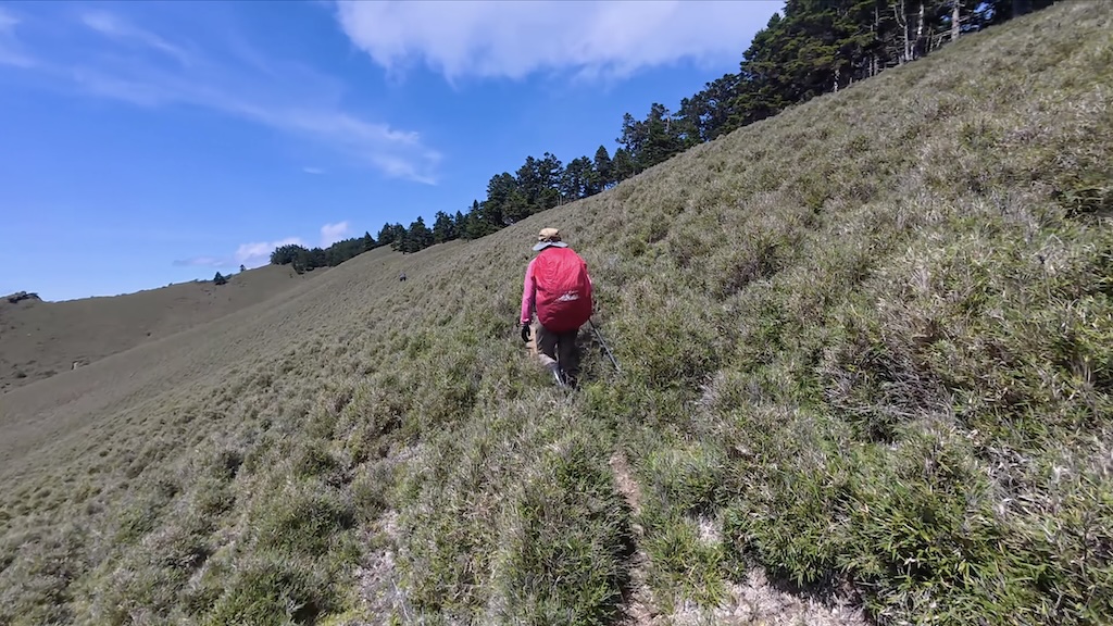
Took a photo and started hiking under the scorching sun.
Menglu Pavilion
Jade Mountain Front Peak
Ⓜ repeatedly emphasized before departure not to let Ⓚ climb the Front Peak, hoping he would save it for last so everyone could celebrate his completion of 100 peaks together. But Ⓚ is the leader, and as a team member I must follow the leader's arrangements! So finally ⓀⓇⒾ spent about an hour climbing the Front Peak, then another hour walking back to the trailhead, while Ⓒ went ahead to Paiyun Lodge to relax. Ⓚ said the stone slope of the Front Peak was the most stable he had walked on, but steep descents still couldn't be done quickly.
During the Mabolasi Crossing, Ⓡ requested that Ⓚ could no longer bring fresh cabbage up the mountain, so this time there was no cabbage, but there was a fresh large pear. Fortunately, most of it was eaten by ⓀⓇⒾ during the rest after descending the Front Peak.
Big Cliff
From this section onwards encountered more hikers, and the weather gradually turned cloudy.
Paiyun Lodge
As we approached Paiyun Lodge, signs of rain began to appear, and I accelerated the last few hundred meters to roll into the lodge. After all four arrived, it started thundering and raining. Seems like Paiyun Lodge can't always disperse the clouds. Ⓚ cooked instant noodles in the cooking area to share. After the rain lightened, we continued on our way. Fortunately, after leaving Paiyun Lodge, the rain almost stopped.
The lodge manager said our progress was a bit late and we needed to be extra careful on the way to Yuan Peak Hut.
Yuan Peak Hut
Arrived at the hut before dark, and the hut was already full of sleeping people! The hut is very old, with wooden exterior walls. Although there are iron sliding doors, they can't seal properly and don't open and close smoothly. The sleeping pads inside are said to be new and thicker, plus the "beds" are raised about 50cm, so no need to lay additional sleeping pads when sleeping (summer). When full, it's very crowded, and moving around requires walking between lying hikers, afraid that one slip would wake up all the hikers in the hut. The hut has water storage, but it tastes like pine needles. There's an independent kitchen where food can be stored, but heard that the nearby weasels and yellow-throated martens are smart enough to open doors, so need to use stones to block the door. Outside there's an ecological toilet (just a pit with two bags of fallen leaves). At the fork before the toilet, you can occasionally get signal, but not all telecom companies have coverage.
One hiker kept grinding his teeth. With this frequency and force of grinding, this hiker definitely won't have tooth loss problems in the future, because the teeth will be ground away before they fall out. Although it was noisy, after listening for a while, it seemed to become gradually acceptable. Just as I was about to fall asleep, suddenly a hiker said: "How am I supposed to sleep like this?" and I woke up, completely alert.
It happened to be a full moon recently, with bright moon and sparse stars.
D2: Jade Mountain South Peak / East Xiaonan Mountain / Lu Mountain
Yuan Peak Hut
Today's itinerary was the most difficult part of the plan, mainly because Lu Mountain is far away with constant ups and downs. To avoid unexpected situations, brought the rain fly along.
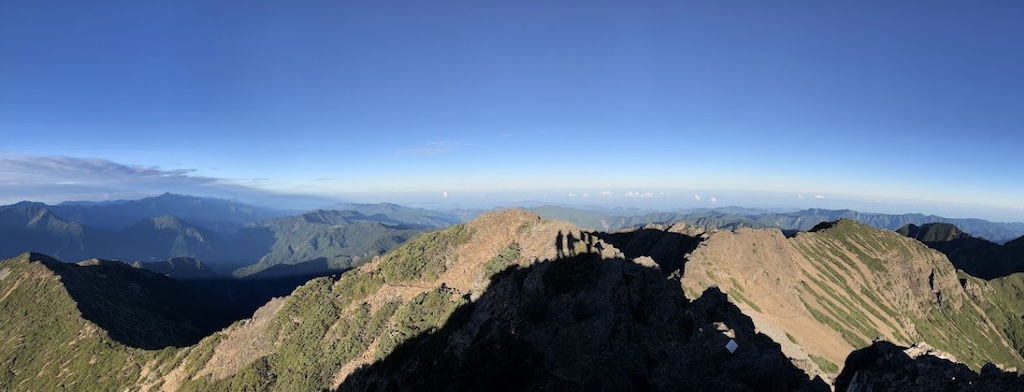
Three-way Peak
On the way to Jade Mountain South Peak, the sun was just rising, and both the ridge and scree slope were dyed orange-red by the sun.
Jade Mountain South Peak
Jade Mountain South Peak is very close, and the uphill path is also very steep. Initially we left the water (main weight) on the path not far from the fork towards South Peak, planning to retrieve it when descending South Peak, but walking down from that slope was also somewhat difficult. Later Ⓚ decided to descend from the other side, so he went back to retrieve all the water bags.
Jade Mountain South Peak was the first terrain requiring climbing in this trip. Because both hands were needed, I didn't bring the camera (later realized I could have just put it in my pocket). After leaving South Peak, we took another route to connect to East Xiaonan Mountain. Passing through steep descending scree slopes required extra caution. Although there were guides along the way, we still went the wrong way once. All this steep descent had to be climbed back at the end.
East Xiaonan Mountain
On the way to East Xiaonan Mountain, mostly walked on the ridge with little terrain. Once went off the path, but after studying the offline map, immediately corrected back.
Three-way junction of South Peak, East Xiaonan Mountain, and Lu Mountain
Before reaching the water source, need to pass through forest, with some sections having fewer guides. We made another wrong turn here. Before the three-way junction, pass through a water source (small stream), but it had been raining for the week before our departure, so not sure if the water source was stable. Not far from the three-way junction, if really short on water on the return trip, could turn back to get water.
Lu Mountain
The trail condition to Lu Mountain was ordinary, mostly walking in the forest. Besides the ups and downs, finally descended below 3000 meters. I stepped on air once on the grass slope in the final section (stepped on weeds, but there was nothing under the weeds), slightly twisted my left foot, fortunately no injury.
Had lunch at Lu Mountain triangulation point, met a couple and shared some food with them.
Three-way junction of South Peak, East Xiaonan Mountain, and Lu Mountain
Three-way Peak
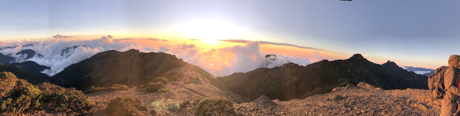
My phone crashed here! Fortunately almost back to the hut! The sun was about to set, and like when we departed at dawn, the mountain walls were dyed orange-red.
Yuan Peak Hut
After restarting, the phone crashed again, had to restart once more to recover. Is my iPhone 8 not going to make it to seven years? The water brought today was just enough. After returning to the hut, was too tired to eat much, only had some sweet soup and snacks. Checked the weather forecast at night, predicted possible rain the next afternoon, but the volunteer's intel was that the chance of rain was lower than today.
D3: Nanyu Mountain
Yuan Peak Hut
Because the previous day was quite tiring, today Ⓚ delayed the departure time to let me continue sleeping until dawn.
Nanyu Mountain fork
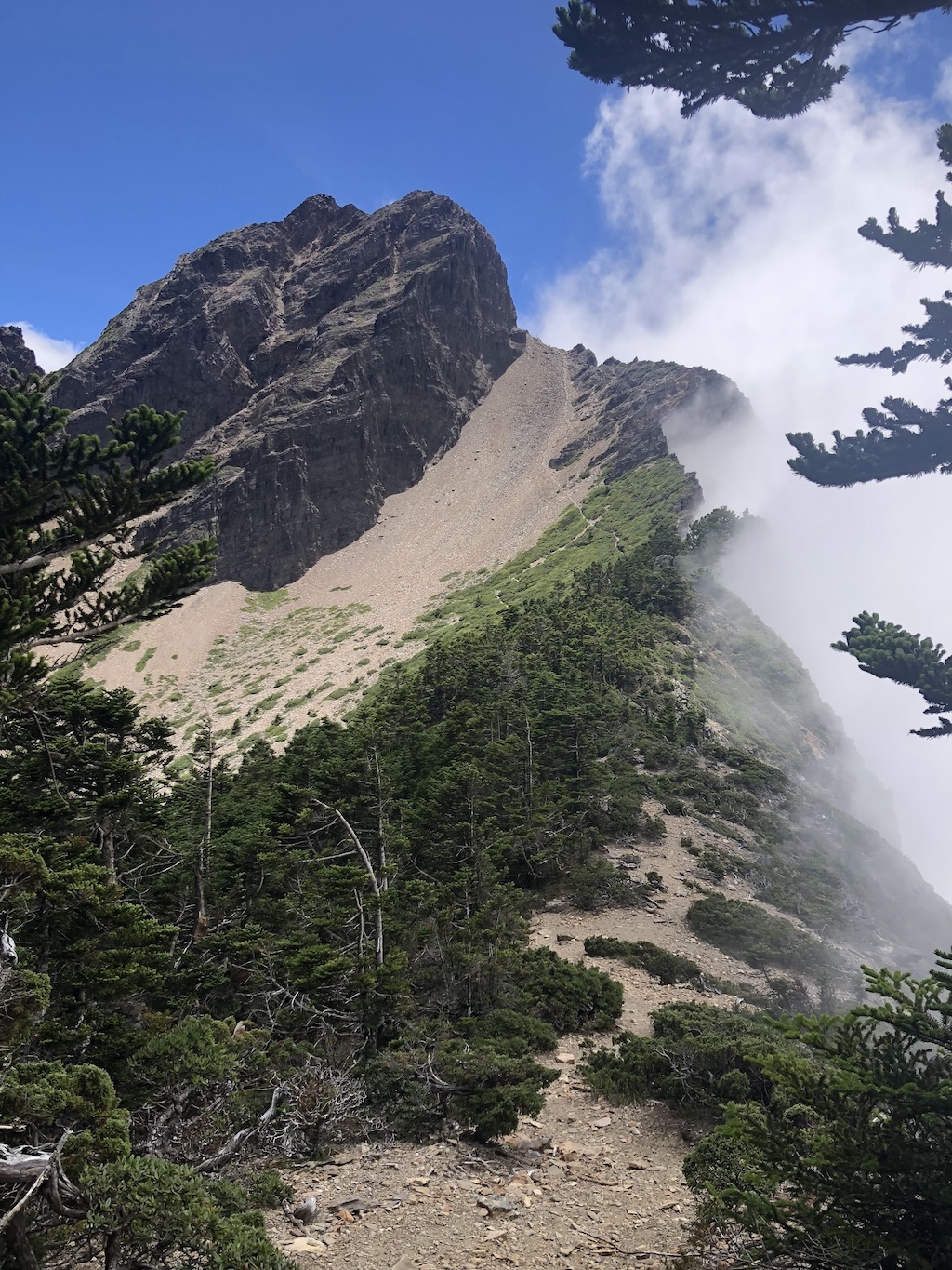
After the fork, first traversed the scree slope, then it was constant steep descent plus terrain crossing (about 2km). Passed through two small mountain gullies with running water along the way. Finally could walk more easily after stepping onto the large grassland. Started encountering returning hikers on the way, each saying it would rain in the afternoon.
Nanyu Mountain
After a brief rest at the triangulation point, considering the rain messages from all sources, decided to head back early.
Jade Mountain Xiaonan Mountain fork
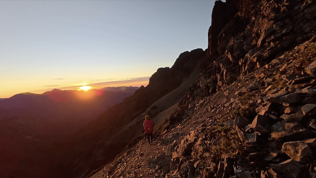
Caught up with the last solo hiker, who had fallen far behind his own team and was planning to climb Jade Mountain Xiaonan Mountain (finally returned to the hut very late). Later large dark clouds started forming in the Yuan Peak direction, and we also tried to speed up. When passing through the small mountain gully, drank some unfiltered water. Although seemed fine, the next day seemed more smooth?!
Nanyu Mountain fork
Climbed the uphill return journey in the clouds and fog. Although three people make rain, finally didn't encounter any rain at all, very lucky.
Yuan Peak Hut
D4: East Peak / Main Peak / North Peak
Yuan Peak Hut
Early in the morning found several heavy backpacks in the kitchen, later learned they were left by hikers who stayed at the campsite the previous night, they had already departed early for Lu Mountain. Today only Ⓚ and I departed, Ⓒ and Ⓡ rested and relaxed near the hut (heard that ⓀⒸⓇ had already been to Jade Mountain from Laonong River before).
Jade Mountain South Ridge fork
Today's itinerary had two options, needed to decide whether to take the route from Paiyun up to Main Peak first, or from South Ridge up to Main Peak. Ⓟ (who didn't come this time) suggested going from South Ridge up to Main Peak, reasoning that the downhill path might be less clear. Looking back, if the trip ended too late requiring night hiking, the danger of this route would greatly increase, and finally would miss this beautiful scenery due to detours.
Met a group of young people on the way, calling themselves "Jade Mountain Front Cooking Team", causing me to think all day: "Probably went to Front Peak, Main Peak, East Peak, West Peak, so which mountain is the 'Front'?"
Jade Mountain Main-East Peak fork
Going up Main Peak via South Ridge, only the beginning section was easier to walk, after that it was all thin ridges or cliffs. With good weather and careful progress, it wasn't difficult. When reaching the Main Peak-East Peak fork, Ⓚ said "Amitabha". Maybe because the temperature was too low, Ⓚ's phone ran out of battery and shut down here. Although the trail should be very obvious, I decided to stop recording the track to save battery.
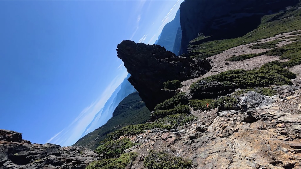
After a brief rest, turned towards East Peak. First was a steep descent, then many paths requiring attention. After passing Phoenix Tail Rock, we left our backpacks under a large rock wall, preparing to climb East Peak with light gear. However, this only looked like a rock wall on the way there, the back was a grass slope. On the return trip, we once thought we had walked past and missed our backpacks.
Jade Mountain East Peak
Climbing East Peak requires using both hands and feet. According to Ⓚ, the current route is more direct, previously it went back and forth and took more time. The main body of the route is steep rock, and some straight sections require maintaining distance from people in front and behind (kicked rocks can roll longer distances due to steepness). Shortly after reaching the summit, the "Jade Mountain Front Cooking Team" also came up. After helping each other take photos, we left first.
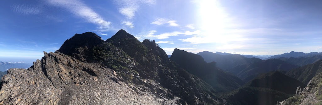
Jade Mountain Main Peak
After returning to the fork, Ⓚ said since it was my first time, let me lead the way up Main Peak, so I walked in front from the fork. After reaching the summit, Ⓚ and I became the two highest men in Taiwan at that moment. The stone tablet was engraved with "Jade Mountain Main Peak", different from the impression of "Pure heart like jade, heavy righteousness like mountain". Found out after descending that the tablet had been replaced.
Today felt some discomfort in my toes along the way, mainly because the calluses on my toes fell off during these few days of hiking, so after reaching Main Peak, put band-aids on my toes. Fortunately no blisters formed in the end.
Soon the "Jade Mountain Front Cooking Team" also reached the summit, and Ⓚ helped take photos of them waving the national flag.
Jade Mountain North Peak
After leaving Main Peak, using the ridge towards North Peak as the boundary, the east was still good weather, while the west was covered with white clouds. After the fork, first was a steep descending scree slope. The large iron poles beside the path were leaning in all directions, looking like they could be uprooted at any moment (actually many iron poles had already been uprooted, just held down by large rocks on the base). When passing the Laonong River fork, couldn't help feeling that my idea of solo climbing to Laonong River campsite was too naive.
When reaching the foot of North Peak, Ⓚ again let me take the lead. There were guide poles along the way, and unsuitable routes were blocked with fallen logs or rocks. There's a weather station on North Peak, with a small space with floor-to-ceiling windows in front of the weather station, containing tables and chairs, but no one was seen at this time. When seeing those tables and chairs, couldn't help hoping there was a refrigerator with cold Coke for sale.
The North Peak triangulation point is behind the weather station. After taking some photos, Ⓚ went alone towards North-North Peak (had been looking forward to going this time before the trip), I was too lazy to move, so took the camera planning to film Ⓚ reaching North-North Peak summit, but Ⓚ returned soon, saying he suddenly didn't want to go up when descending to the low point.
At this time, the North-North Peak direction was full of clouds and fog, only the Main Peak direction had no clouds. After resting, we started heading back. The downhill after leaving the weather station was particularly hot for some reason, felt like I could get sunburned even through clothes, fortunately it was just a feeling. It was very hot all the way, only the forest section could slightly relieve the heat.
Looking at the scree slope, couldn't believe we had just walked down from this steep slope. Halfway through, looking towards the eastern valley, thought the scenery was nice, but immediately dismissed the idea of taking photos in the rockfall area.
After returning to the fork, headed towards Paiyun Lodge, taking the regular route back to the hut.
Yuan Peak Hut
When returning to the hut, Ⓡ had already cooked milk tea red bean soup to replenish Ⓚ and me. Then Ⓡ cooked rice for everyone, adding many ingredients to the soup, taking a different route from Ⓚ's light style. Ⓡ also said this was her new height for closed-pot cooking (highest altitude ever), and it came out without burnt rice.
When it was about to get dark, the owners of the heavy backpacks in the kitchen finally returned to the hut. Two hikers returned first, the leader went to pack up the tent first, another asked Ⓚ to help move the heavy backpacks from the kitchen into the hut. Good guy Ⓚ went to help. After moving, they wanted to ask Ⓚ to help pack up the tent (🤷🏻), fortunately Ⓚ refused.
At night, only two teams remained in the hut, finally could rest in spacious conditions. However, the two hikers next door were very talkative, waking up at 3 AM and continuing to chat. Originally thought they were preparing to go to Nanyu Mountain, but after going to the bathroom, came back and continued chatting. The diagonal sleeping posture of the neighboring hiker gradually leaned onto my feet, and after going to the bathroom, sat on my feet, making me think I had slept crookedly.
D5: Yuan Peak Hut ⇢ West Peak ⇢ Taipei
Yuan Peak Hut
It was a full moon these few days, couldn't see many stars at night, but before dawn still saw Orion's Belt (one of the two constellations I recognize, the other is the Big Dipper).
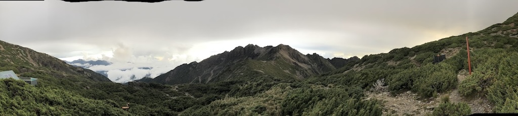
Paiyun Lodge
After storing the large backpacks in the drying room beside the lodge entrance, departed lightly for West Peak. However, I didn't bring a small backpack, so Ⓒ helped me carry the water bottle. Saw a yellow-throated marten at the trailhead, but wasn't fast enough to film it.
Jade Mountain West Peak
No difficult terrain, but the accumulated fatigue from these few days made even small uphills feel tiring. There were some open sections on the way to West Peak, which should have offered nice scenery, but these few days had already been hit by various beautiful views, so this level of scenery couldn't attract my attention anymore. The whole route felt like a mid-level mountain, and at the triangulation point, could see indifferent sea of clouds through tree gaps. West Peak was also the only Jade Mountain hundred peak that none of the four had climbed before.
Paiyun Lodge
There's a large map board outside Paiyun Lodge, the suggested route was almost the same as ours. When Ⓚ was taking a group photo with the board, mentioned that it was his fourth time here to complete all nine Jade Mountain hundred peaks, and I was very lucky to complete them on my first trip (first application, first hike 🍀).
After some adjustments, continued on our way. Ⓡ estimated that 2km/h would allow us to meet the shuttle comfortably, but everyone rushed to Tatajia at 3km/h.
Tataka Trailhead
At the trailhead, remembered reaching Tatajia for the first time via Linzhi Mountain several years ago, looked it up and found it was three years ago tomorrow. Then started hiking frequently, completing Jade Mountain Nine Peaks three years later.
Dongpu Mountain Villa, board shuttle
Signs of rain began to appear, and we lucky ones boarded the shuttle before it rained. On the car, I received an evaluation: big appetite is a weakness (I'm just helping everyone solve problems 🤣).
We asked the shuttle driver to take us to McDonald's first, but when we reached the McDonald's at the bottom of the mountain, encountered heavy rain, so we lost interest and held out until Taian rest stop to eat.
Yuanshan Transfer Station
Went back to my hometown to visit, and mooched a meal from my mother 🤤.
Miscellaneous Notes
- Saw a vinaceous rosefinch (introduced by Ⓡ, I originally didn't recognize it), this is one of the only two bird species I can recognize in high mountains besides the white-whiskered laughingthrush.
- ⒸⓇ and I unanimously agree that Ⓚ is "most tired in the moment, but will say it was very easy after it's over".
- It's easy to see "Jade Mountain thistle" along the trail, but when on the mountain, I could only remember it was "some kind of thistle".
- Very lucky with weather, Taiwan had continuous typhoons and heavy rain after the Mabolasi Crossing, until we went to Jade Mountain when there were five consecutive days of good weather.
- When returning from Lu Mountain, my sunglasses couldn't block the sunset, and my eyes ached so much they were tearing up.
- It's easy to see Lulin Observatory, remember going there once during university.
- Nana went grocery shopping on the last day, and after buying groceries, heard Bobo say he wanted to eat a big watermelon, so went to buy a large piece home ❤️.