Mabolasi Crossing: 8-Day Trek
Summer 2025, completing the Mabolasi Crossing in eight days.
D0: Taipei ⇢ Dongpu Xiaosong Guesthouse
Yuanshan MRT Station
Had lunch at a department gathering at INPARADISE Breeze Xinyi Branch, the view from the 46th floor was quite nice. However, I didn't dare eat much, fearing indigestion would affect the upcoming trip.
During this period, I constantly studied the route and pack weight. Finally, it was time to put it all to the test in this nine-day journey. The weather forecast was generally good, though the 10-day forecast indicated a possible typhoon formation towards the end of our trip.
In the afternoon, we gathered at Yuanshan MRT Station. I carried my heavy pack with a climbing helmet attached, boarded the MRT and arrived on time. I wasn't very familiar with most of my teammates yet, feeling both quiet and expectant. After gathering, the cars split into two routes. My route first went to Linkou to pick up Ⓦ. We ate the lunch boxes prepared by Ⓚ at a rest stop. As we approached central Taiwan, heavy rain began, and we witnessed several lightning strikes hitting the ground - quite spectacular.
Xiaosong Guesthouse
Arrived at Xiaosong Guesthouse. After room assignments, we began eating - there were lychees and oranges. Ⓚ started distributing group gear.
Sleep
Although we went to bed early tonight, this was the latest bedtime of the entire trip. The room was very hot in the first half of the night, and I only slept in short fragments throughout the night.
D1: Dongpu Xiaosong Guesthouse ⇢ Guangao Cabin
Xiaosong Guesthouse
Had breakfast at the guesthouse the next morning. As usual, I made a cup of coffee - drinking one before hiking always helps me wake up and get into the right mindset.
Then we went to Jade Mountain National Park's Dongpu Service Center to handle entry procedures. However, we arrived early and the service center wasn't open yet, and we couldn't find any restrooms outside. There was a stone slab cabin at the entrance, carrying both ancient traditional aromas and modern craftsmanship marks.
After arriving at the trailhead, we made brief preparations and handed some group gear and food to Ⓠ for him to carry, allowing us to hike more comfortably. The Aiyu pavilion wasn't open for business yet. Although we wouldn't specifically want aiyu early in the morning, it was still a bit disappointing not to see the legendary pavilion on this rare visit.
Batongguan Historic Trail West Section
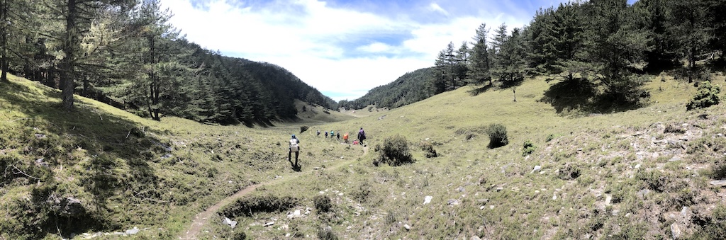
Proceeded along the Batongguan Historic Trail West Section, with Duiguan Mountain across the Chenyoulan River on our right. I was somewhat absent-minded at first - not due to any worries, just easily distracted. I kept reminding myself to return to reality and watch the trail conditions, while also beginning to understand the meaning of "living in the moment."
Yunlong Suspension Bridge
Lele Cabin
Arrived at Lele Cabin (Lele Police Outpost) for lunch. Ⓚ cooked noodles and tea for everyone to share.
During lunch, signs of rain began, and at one point we heard heavy rain. Thinking that if my hiking boots got soaked on the first day, the next eight days would be quite miserable, I immediately put on my rain jacket and rain pants. Indeed, wearing rain gear works - as long as you're willing to wear it, the rain won't be heavy. This mystical hiking law was verified once again.
Guangao Ping
When gathering at Guangaoping, Ⓚ seemed to have cramps from carrying too much group gear, indicating that the food for the next few days would be quite luxurious.
Along the way, Ⓦ said something like "just one more turn and we'll be there," which immediately became a classic quote. From then on, whenever she estimated distance or time, everyone would automatically multiply by a conservative factor. Although joking, it made the atmosphere much more relaxed.
Guangao Cabin
Arrived at Guangao Cabin.
The manager briefly introduced the cabin rules. Most notable was the slipper system - there were three sets: one for going outside the cabin, one for use inside the cabin, and another for kitchen use only. Not sure how long such a system can be maintained, but at least it was well-organized for now.
To the right of the entrance was a small room specifically for storing wet gear, where rain jackets, rain pants, etc., could be centrally placed to drip dry.
Our team exactly filled one room. Since it was currently a trial operation period, even the sleeping pads were brand new, so new that the plastic packaging hadn't been removed yet. Although they looked very clean, they were somewhat uncomfortable to sleep on and took some time to get used to.
Before dark, we could still charge devices in the common area, though the power output wasn't strong and charging was slow. Ⓚ first cooked some red bean soup for everyone to share - the hot soup was perfect for this damp, cool weather. After waiting a while, Ⓠ also arrived with the remaining gear. I heard that mountain activities have generally cooled down recently, so Ⓠ has fewer porter jobs. The first day was still considered a warm-up. Coincidentally, one of the managers was actually Ⓠ's friend, who was worried about rain conditions and specifically went out to meet him.
D2: Guangao Cabin ⇢ Baiyang Gold Mine Cabin
Guangao Cabin
Departed from Guangao Cabin, following the high traverse route toward Batongguan. There were quite a few minor terrain features to navigate. After passing through one small terrain section, I encountered stinging nettle for the first time in my life - my left palm felt like I had eaten spicy hotpot, with the aftereffect lasting until evening.
On the trail, we met a small team preparing to retreat. They had originally planned to hike the "Eight Big Show" but one member was injured, so they were heading down early.
Batongguan Police Outpost
Located in the valley between Batongguan Mountain and Jade Mountain, there are no buildings left at the site, only traces of stones stacked and leveled.
In middle school, I often saw an article titled "All About Batongguan," possibly from Chinese literature exam archives. Although I never read it carefully then, I was deeply impressed by the place name "Batongguan" and longed to visit. Now I finally came here in person.
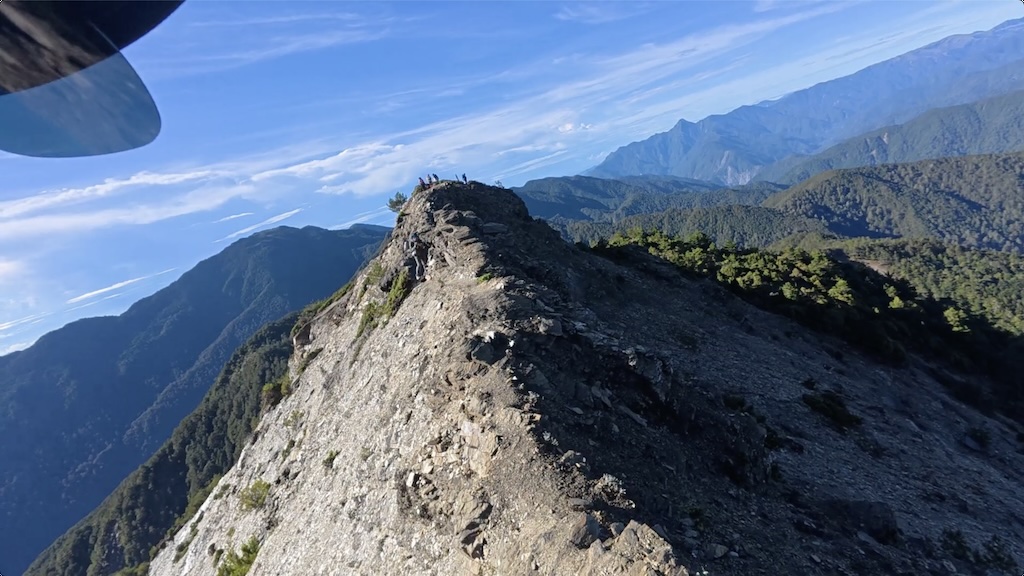
Batongguan Mountain Trailhead
We took a brief rest at Batongguan Mountain trailhead. Most team members had summited before, so they planned to skip it this time and continue directly. Someone encouraged Ⓡ to go up, but Ⓡ wasn't interested and didn't participate. Finally, Ⓚ and Ⓦ led me, Ⓐ, and Ⓒ to the triangulation point. I borrowed a small pack from Ⓟ, packed water and some snacks, carried my camera and one trekking pole, and set off after simple preparation.
Batongguan West Peak Junction
Met a heavily loaded father and daughter pair. The little girl looked only about ten years old, planning to do a light pack day hike to Batongguan Mountain then take the West Peak route to Guangao Cabin.
Batongguan Mountain
Reached Batongguan Mountain, the first 100 Peaks of Taiwan of this trip. The weather was excellent, offering panoramic mountain views.
Batongguan Mountain Trailhead
When we returned to Batongguan Mountain trailhead, we met Ⓠ who had started later. After a brief rest, we continued forward.
Near Banaiyike Campsite, we took a wrong turn at one point. The direction ahead seemed like the original route, but the trail was unclear and there might be difficult terrain to pass. We ultimately decided to turn back and take the obvious high traverse route.
Central Gold Mine Cabin
Arrived at Central Gold Mine Cabin, where Ⓠ was also resting. We went to the nearby Laonong River to get water.
Mist began to form on the trail, and my energy was nearly depleted. I could only walk slowly to the cabin.
Baiyang Gold Mine Cabin
After arriving at the cabin, we found the space quite small, and some team members spotted mice. There was a stream outside, and across the stream on the cliff wall was a cave, said to be remnants of an old gold mine. There certainly wasn't any gold, but I was too tired then to have the energy to go gold panning anyway.
My energy was clearly overdrawn, and I joked that Ⓡ's decision not to climb Batongguan Mountain was the right one. My appetite was poor - for dinner I only had a bowl of grass jelly dessert and some corn soup, then went to bed early.
D3: Baiyang Gold Mine Cabin ⇢ Mabo Cabin
Baiyang Gold Mine Cabin
Departed from Baiyang Gold Mine Cabin. Before leaving, I took a special look at the legendary gold mine across the stream. The route went up along scree slopes, stepping on loose rocks to reach Xiuguping. Then we entered the traverse section, where the path gradually approached the cliff face. The terrain changed significantly along the way, requiring careful passage. After reaching Xiuguluan Mountain trailhead, the team decided to continue traversing to the other side's trailhead, then summit with light packs.
Xiuguluan Mountain North Trailhead
Reached the north trailhead, where there was an abandoned workers' lodge. It was very windy, but crossing a small hill toward Xiuguluan Mountain provided some wind shelter.
Xiuguluan Mountain
Reached the summit of Xiuguluan Mountain. Fog began forming before arrival - this was the only peak of the entire traverse surrounded by white walls.
Xiuguluan Mountain North Trailhead
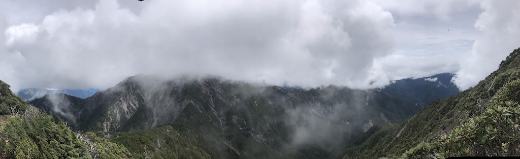
Junction Before Mabolasi Mountain
After reaching the junction, we rested briefly for about 15 minutes, then headed directly to Mabo Cabin. Ⓚ and Ⓦ took the opportunity to visit Mabolasi Mountain first. Including tomorrow's itinerary, they would summit three times total on this traverse.
Mabo Cabin
From the junction, we descended about 150 meters to reach Mabo Cabin. This section had dense cypress trees, and I somewhat lost sense of distance while walking. The cabin suddenly appeared around a corner. Not far in front of the cabin, we could see a sea of clouds, and the surrounding forest looked like a perfect picnic spot. It started raining at midnight and continued until we departed.
D4: Mabo Cabin ⇢ Jyupen Mountain ⇢ Mabo Cabin
Mabo Cabin
Departed from Mabo Cabin. We heard that the yellow-throated martens nearby were quite mischievous, so everyone carefully hid their food. ⓜ's extra-large dry bag came in handy at this time. We climbed 150 meters back to the junction, where the rain had stopped, though the weather was still unstable.
Mabolasi Mountain
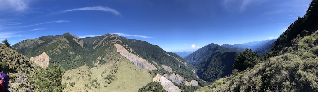
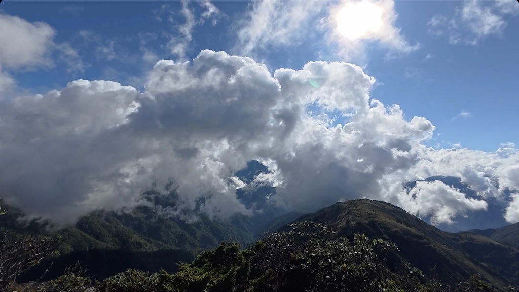
Reached Mabolasi Mountain, surrounded by white walls on all sides. Since the day's journey was still long, we only took a quick summit photo before continuing forward. After descending, we proceeded along the ridge. Although the rain had stopped, we were still surrounded by clouds and mist, with occasional strong winds that made traversing the terrain somewhat nerve-wracking.
The clouds occasionally parted, revealing glimpses of Jyupen South Peak. After passing the south peak, the weather suddenly cleared, and we endured the blazing sun for the rest of the day. The section before Jyupen Middle Peak was mostly open grassland with excellent views. Along the way, Ⓒ mentioned that "I want to pick up antlers" was their code phrase for tying shoelaces.
We took a long break at the saddle before Jyupen Middle Peak, planning to have lunch at the same spot after returning from Jyupen Mountain. There was a dried-up seasonal pond here. Ⓦ spotted what looked like antlers at the edge of the distant forest and excitedly ran over to check (literally jogging, as the phrase suggests), but it turned out to be nothing.
When we reached the junction at the base of Jyupen Mountain, we encountered another team. This team would also stay at Mabo Cabin tonight. We knew about this group before departure and guessed we'd meet them on this section. I had even quietly hoped that if they canceled their trip, we could continue to have the cabin to ourselves.
Jyupen Mountain
Reached Jyupen Mountain triangulation point. There was an aluminum basin next to the triangulation point, and everyone began taking creative photos with it, coming up with various imaginative poses.
We asked the fellow hikers we had just met to help take group photos. They all looked quite skilled, having completed their heavy pack hike from another route in just two days (this was our fourth day).
We decided to take a long break on the grassy slope below, enjoying mountain views while eating lunch. The weather remained clear, and the entire grassland was warmed by the sun. I also took the opportunity to take off my shoes and socks to dry them.
Before Jyupen Mountain
Started the return journey, splitting into front and rear groups. I was naturally in the slower rear group.
The return weather was excellent, climbing nearly 800 meters under the blazing sun. My energy ran out in the latter half, walking with frequent stops and unable to eat snacks.
Mabolasi Mountain
Returned to Mabolasi Mountain triangulation point. The weather was beautiful, with half the surroundings being clouds and the other half clear gaps revealing distant peaks. On Taiwan's fourth highest peak, the clouds seemed like cotton candy within arm's reach.
Mabo Cabin
Returned to Mabo Cabin, where the front group had prepared sweet soup, perfectly replenishing the energy lost throughout the day.
This day was so exhausting that we ultimately decided to cancel tomorrow's trip to Tanxi Bay and descend a day early. Actually, this decision was a relief to me - if we hadn't canceled, I would have been torn between wanting to see it and worrying about insufficient energy.
The weather was excellent tonight. When I walked out of the cabin at midnight, I could clearly see the Milky Way. Unfortunately, I just wanted to get back to the cabin to sleep and had no mood to try photographing the starry sky.
D5: Mabo Cabin ⇢ Malijianan East Peak Cabin
Mabo Cabin
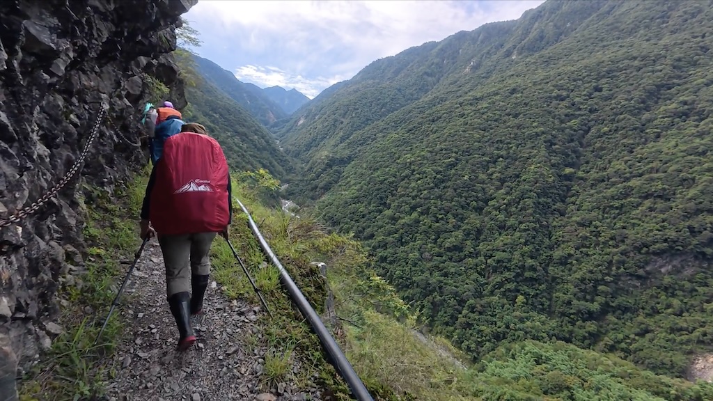
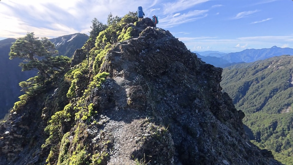
Departed from Mabo Cabin. We woke up later today, partly because yesterday was so exhausting, and partly because today's itinerary was relatively shorter. However, passing through Wulameng Cliff required more concentration. Although Wulameng Cliff was dangerous, it also offered magnificent scenery. Ⓠ stood in the middle section of the cliff helping everyone adjust rope positions, allowing those behind to pass through more smoothly.
Malijianan Mountain
Reached Malijianan Mountain. Just before reaching the triangulation point, my memory card suddenly became full. It turned out that when I initially estimated space, I based it on HD quality, but just before departure I changed the video quality to 4K, so the card filled up halfway through the trip. I switched to the camera's internal storage for the remaining footage, recording in HD.
Malijianan East Peak Cabin
Arrived at Malijianan East Peak Cabin, sharing accommodation with the same team we met at Jyupen Mountain.
D6: Malijianan East Peak Cabin ⇢ Mabu Valley Cabin
Malijianan East Peak Cabin
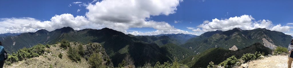
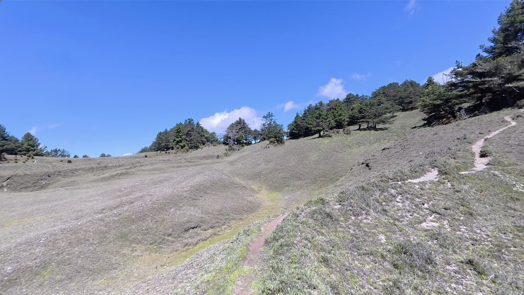
Departed from Malijianan East Peak Cabin, first climbing Tabila East Mountain to check in (the cabin had no signal). The mountaintop was a vast grassland where, besides the surrounding mountains, we could see all the way to the Pacific Ocean.
Then we traversed Tabila Cliff. While Wulameng Cliff still had rock walls to lean against, here we walked on an exposed ridge with no shelter on either side. I focused my attention on the narrow path beneath my feet, leaving the surrounding scenery to the camera on my shoulder to capture for later enjoyment at home.
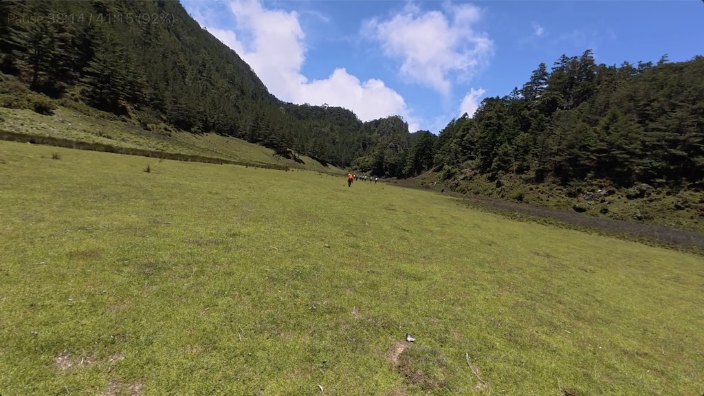
Mabu Valley Cabin
Arrived at Mabu Valley Cabin. Mabu Valley is a long, narrow valley with gentle terrain - the most relaxed and leisurely section of the entire traverse.
Everyone took photos in front of the cabin. Ⓚ and Ⓗ went downstream along the valley looking for water but didn't find any. I lay in the cabin trying to take an afternoon nap but couldn't fall asleep.
During the afternoon break, ⓜ introduced everyone to PAC (Portable Altitude Chamber). If I hadn't seen it with my own eyes, I would have thought you had to stuff people into the blue barrel.
Everyone was seriously replenishing calories, but trail food was running low. Hearing that tomorrow's itinerary would be tough, I shared my remaining food. Surprisingly, the almond protein powder and Natural Valley crunch bars were very popular.
Mabu Valley Cabin
When I got up to set up the camera, there were pairs of eyes glowing on the hillside. I heard that the Formosan rock macaques here are more afraid of humans, unlike those in other areas that approach people. I took a photo in front of the cabin, then placed the camera on the water tank, setting up time-lapse photography facing north, planning to wake up at 03:00 the next day, just in time to record the camera's maximum length of five hours. Since we had to wake up even earlier the next day, I wore earplugs to rest at midnight. The effect was surprisingly good - I slept for three solid hours. Looking at ⓜ's photos afterward, I discovered that Ⓠ had written in the logbook wishing us a safe journey.
D7: Mabu Valley Cabin ⇢ 35K Workers' Lodge
Mabu Valley Cabin
Today's distance was very long, so we departed from Mabu Valley Cabin in the dark. We planned to get water at Taiping Valley, so everyone carried relatively little water.
Maxi Mountain
Light pack summit of Maxi Mountain, which is a round peak. It was so windy that we couldn't use trekking poles as a phone tripod, so I used my camera with a short tripod to record group photos. The trail was somewhat confusing, but with careful searching we could still follow the correct route.
Kaxipanan Mountain
Reached Kaxipanan Mountain triangulation point, the last 100-peak of this traverse. Half the surroundings were sea of clouds, half were mountain ranges. Then we descended steeply toward Taiping Valley. Although the weather was good, the ground was covered with dry fallen leaves that were particularly slippery, requiring careful steps. The forest composition gradually changed, beginning to take on the appearance of mid-altitude mountains.
Taiping Valley
Reached Taiping Valley. We had originally planned to take a long break here for water and lunch, but the entire valley had only two pools of stagnant water. The team we met at Malijianan Cabin had planned to camp here yesterday, only to discover no running water when they arrived - they must have been quite speechless. We rested here and ate some dry food. The valley was still beautiful, just with taller ground vegetation compared to Mabu Valley. Afterward, we went up and down along the stream valley, rejoining the forest road, though there were multiple collapses along the way, making it another series of ups and downs. As elevation decreased, humidity increased, and slippery sections became more frequent.
35K Workers' Lodge
After arriving at the 35K Workers' Lodge, we first prepared our overnight accommodations. We pitched two tents, with some people sleeping under tarps and others squeezing into the workers' shelter. After dinner, the weather suddenly changed and heavy rain began. The hastily erected tarp started leaking (low water resistance plus poor setup). I was worried about my down sleeping gear getting wet and originally planned to sleep in my rain jacket, but as the rain lessened, I gave up on that idea. I took out my quilt and hastily fashioned it into a sleeping bag shape in the dark, then collapsed to sleep. Unexpectedly, this turned out to be the deepest sleep of the entire traverse.
D8: 35K Workers' Lodge ⇢ Taipei
35K Workers' Lodge
We departed before dawn (around 04:00), planning to hike for seven hours to catch the shuttle. Along the way, we were either crossing streams or battling collapsed forest roads, with constant ups and downs that were quite exhausting.
Zhongping Forest Trail Terminus
The shuttle driver had prepared a bottle of cola and a meat dumpling for each person, then we rode the bumpy vehicle to complete the remaining forest road.
Yuli
Arrived in Yuli, first went to Walami Guesthouse to wash up, then our group began eating noodles, ice cream, and stinky tofu. Under the blazing sun, we ate our way around the streets. Looking up, the mountains were already covered with dark clouds - our luck on this trip was unbelievably good.
While waiting for stinky tofu, we stopped by the Taiwan Black Bear Education Center. We originally just wanted to enjoy some air conditioning and kill time, but unexpectedly gained a wealth of knowledge. The staff enthusiastically introduced various bear species and Taiwan wildlife, and explained methods and equipment for tracking black bears, which was quite eye-opening.
Before the train departed, everyone bought quite a bit of food supplies. However, I was already full and only brought a bottle of black tea on board. After the train started, I stared out the window in a daze, took out my phone to play Sudoku, while others had already started uploading photos, as if the journey wasn't over but had just continued in a different way.
Taipei
Arrived in Taipei, transferred to MRT to go home.
Notes
- In the first two days, my head occasionally felt strange, not uncomfortable, presumably part of the altitude adaptation process. The feeling disappeared after breathing heavily while climbing uphill.
- Although I ended up sharing all my trail food because the team ran short, this showed I had brought too much.
- Knowing that team members had completed the Mabolasi Crossing before was quite reassuring.